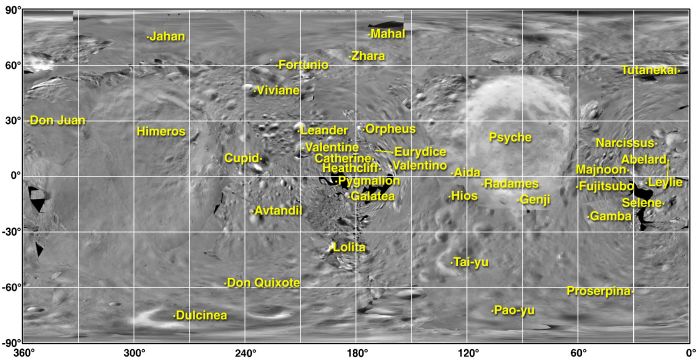
The Map Of Eros
Explanation:
This map
of Eros
was constructed from a mosaic of images recorded by the
NEAR Shoemaker spacecraft, currently orbiting the 40 x 14 x 14
kilometer asteroid.
A simple
cylindrical projection of an irregularly
shaped
world, the map's individual images don't always match up at
the edges.
Shown here, place names have been
proposed to describe the geography
of Eros with a fitting theme, though.
They are based on romantic figures in the history and
literature of the cultures of planet Earth.
The largest feature,
Himeros,
is a depression about 10 kilometers wide.
In
Greek mythology,
Himeros was an attendant of Eros and the
personification of the longing of love.
Today, after safely
surveying Eros
for the past eight months, NEAR Shoemaker
is scheduled to make a
daring close
approach to the asteroid,
briefly flying to within about 6 kilometers of its surface.
Images returned
from that distance are expected to show
features less than 1 meter across.
Authors & editors:
Robert Nemiroff
(MTU) &
Jerry Bonnell
(USRA)
NASA Web Site Statements, Warnings,
and Disclaimers
NASA Official: Jay Norris.
Specific
rights apply.
A service of:
LHEA at
NASA /
GSFC
& Michigan Tech. U.
