Ancient Ogunquit Beach on Mars
Explanation:
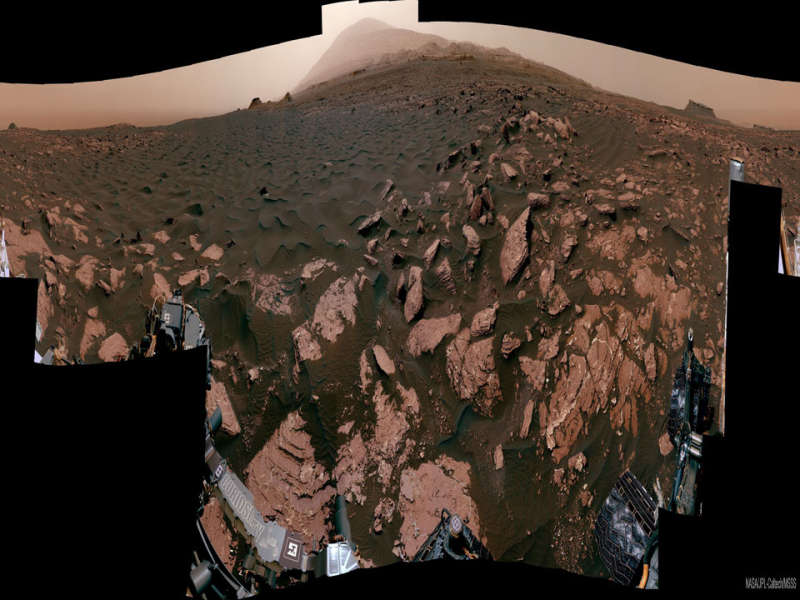
This was once a beach -- on ancient Mars.
The featured 360-degree panorama,
horizontally compressed, was taken by the robotic
Curiosity rover
currently exploring the
red planet.
Named
Ogunquit Beach after its
terrestrial counterpart,
evidence shows that at times long ago the area was underwater,
while at other times it was at the edge of an
ancient
lake.
The light peak in the central background is the top of
Mount Sharp, the central feature in
Gale Crater where Curiosity has been deployed.
Curiosity is slowly ascending Mount Sharp.
Portions of the
dark sands in the foreground have been
scooped up for analysis.
The light colored
bedrock is composed of
sediment
that likely settled at the bottom of the now-dried lakebed.
The featured panorama
(interactive version here)
was created from over 100 images acquired in late March and seemingly signed by the
rover on the lower left.
Currently, Curiosity is carefully crossing deep
megaripples
of dark sands on
its way to explore
Vera Rubin
Ridge.
Explore the Universe:
Random APOD Generator
Authors & editors:
Robert Nemiroff
(MTU) &
Jerry Bonnell
(USRA)
NASA Web Site Statements, Warnings,
and Disclaimers
NASA Official: Jay Norris.
Specific
rights apply.
A service of:
LHEA at
NASA /
GSFC
& Michigan Tech. U.
