|
|
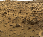
You entered: Surveyor
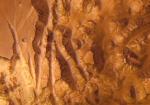 Valles Marineris from Mars Express
24.01.2004
Looking down from orbit on January 14, ESA's Mars Express spacecraft scanned a 1700 by 65 kilometer swath across Valles Marineris - the Grand Canyon of Mars - with its remarkable High Resolution Stereo Camera.
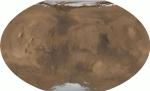
 Mapping Mars
19.03.1999
This month, the Mars Global Surveyor (MGS) spacecraft began its primary mission to the red planet. Orbiting about once every two hours at an altitude of over 200 miles, instruments onboard MGS now regularly explore the Martian surface and atmosphere.
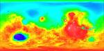 Topographical Mars
28.05.1999
Contrasting colors trace changing elevations in this new high-resolution topographic map of Mars. Just released, the data were gathered in 1998 and 1999 by the Mars Orbiter Laser Altimeter (MOLA) onboard the Mars Global Surveyor spacecraft.
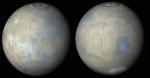
 All of Mars
26.06.2001
From pole to pole, from east to west, this is all of Mars. The above picture was digitally reconstructed from over 200 million laser altimeter measurements taken by the Mars Global Surveyor spacecraft currently orbiting Mars.
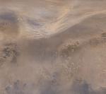 Dust Storm Over Northern Mars
10.07.2003
Almost on cue, as Mars nears it's closest approach to planet Earth in recorded history, ominous seasonal dust storms are beginning to kick up. Observers worry that the activity may presage the development...
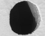 A Hole in Mars Close Up
28.09.2007
In a close-up from the HiRISE instrument onboard the Mars Reconnaissance Orbiter, this mysterious dark pit, about 150 meters across, lies on the north slope of ancient martian volcano Arsia Mons. Lacking raised rims...
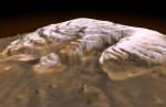 3-D Mars North Pole
16.12.1998
This dramatic premier three-dimensional visualization of Mars' north pole is based on elevation measurements made by an orbiting laser. During the Spring and Summer of 1998 the Mars Orbiter Laser Altimeter (MOLA) flashed laser pulses toward the Martian surface from the Global Surveyor spacecraft and recorded the time it took to detect the reflection.
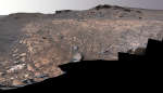 Perseverance in Jezero Crater s Delta
17.09.2022
The Perseverance rover's Mastcam-Z captured images to create this mosaic on August 4, 2022. The car-sized robot was continuing its exploration of the fan-shaped delta of a river that, billions of years ago, flowed into Jezero Crater on Mars.
 20 Years Ago: Vikings on Mars
20.07.1996
On July 20, 1976, NASA's Viking 1 lander become the first spacecraft to land on Mars, followed weeks later by its twin robot explorer, the Viking 2 lander. Operating on the Martian surface...
 The Shadow of Phobos
29.03.2003
Hurtling through space above the Red Planet, potato-shaped Phobos completes an orbit of Mars in less than eight hours. In fact, since its orbital period is shorter than the planet's rotation period, Mars-based...
|
January February March April |
|||||||||||||||||||||||||||||||||||||||||||||||||