|
|
You entered: hurricane
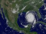 Hurricane Katrina in the Gulf of Mexico
29.08.2005
Where will Hurricane Katrina go? One of the stronger storm systems of modern times appears headed for landfall somewhere in the southern USA sometime today. Katrina was designated yesterday a rare Category 5 Hurricane, the strongest designation for a storm on Earth, and one that indicates sustained winds greater than 250 kilometers per hour.
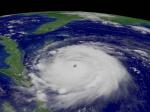 Hurricane Frances Approaches Florida
3.09.2004
A major hurricane is heading for Florida. Hurricane Frances, one of the stronger storm systems of modern times, may cross the eastern coast of Florida sometime tomorrow. Those in the path of a hurricane should take precautions. For example, NASA's Kennedy Space Center has completely shut down.
 Hurricane Season Animated
27.11.2017
Where do hurricanes go? To better understand dangerous storms, NASA compiled data from several satellites into a supercomputer simulation of this past year's hurricane season. Specifically, the featured video shows how smoke (white), sea salt (blue), and dust (brown) tracked from 2017 August through October across the northern half of Earth's Western Hemisphere.
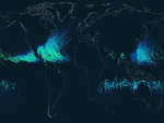 Hurricane Paths on Planet Earth
4.09.2012
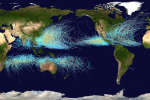
Should you be worried about hurricanes? To find out, it is useful to know where hurricanes have gone in the past. The above Earth map shows the path of every hurricane reported since 1851, Although striking, a growing incompleteness exists in the data the further one looks back in time.
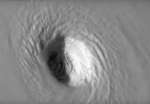 Swirling Around the Eye of Hurricane Irma
10.09.2017
Why does a hurricane have an eye at its center? No one is yet sure. What happens in and around a hurricane's eye is well documented, though. Warm air rises around the eye's edges, cools, swirls, and spreads out over the large storm, sinking primarily at the far edges.
 Cyclone Paths on Planet Earth
15.09.2021
Where on Earth do cyclones go? Known as hurricanes when in the Atlantic Ocean and typhoons when in the Pacific, the featured map shows the path of all major storms from 1985 through 2005. The map shows graphically that cyclones usually occur over water, which makes sense since evaporating warm water gives them energy.
 Superstorm Sandy From Formation to Landfall
7.11.2012
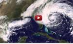
It was the largest hurricane ever recorded in the Atlantic Ocean. The cost of its devastation is still unknown. Pictured above is a movie of Superstorm Sandy taken by the Earth-orbiting GOES-13 satellite over...
 Jupiter from Voyager
25.06.1995
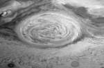
Imagine a hurricane that lasted for 300 years! This picture of the planet Jupiter was taken by the Voyager 1 spacecraft as it passed the planet in 1979. Jupiter, a gas giant planet with no solid surface, is the largest planet in the solar system and is made mostly of the hydrogen and helium.
 Galileo, Cassini, and the Great Red Spot
2.08.1996
Imagine a hurricane that lasted for 300 years! Jupiter's Great Red Spot indeed seems to be a giant hurricane-like storm system rotating with the Jovian clouds. Observed in 1655 by Italian-French astronomer Jean-Dominique Cassini it is seen here over 300 years later - still going strong - in a mosaic of recent Galileo spacecraft images.
 The Winds of Earth
10.10.2016
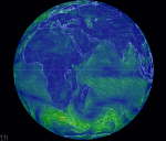
Which way is the wind blowing? The featured map can tell you this and much more, no matter your location on planet Earth. The dynamic map displays supercomputer forecasts drawn from multiple sources of global satellite data updated every three hours.
|
January February March April May June July |
|||||||||||||||||||||||||||||||||||||||||||||||||