|
|
You entered: surveyor 6
 Mars: A Canyon's Edge
18.03.1998
High resolution Mars Global Surveyor images were combined with Viking Orbiter color data to produce this stunning, detailed view of a Martian canyon's edge. The area pictured is about 6 miles wide and represents a tiny part of the northern edge of the canyon Valles Marineris, whose total length is about 2,500 miles.
 Destination: Moon
7.01.1998
Tuesday, January 6, at 9:28 p.m. EST, NASA's Lunar Prospector spacecraft climbed into the sky above Cape Canaveral Air Station riding an Athena II rocket. Representing NASA's first Moon mission since...
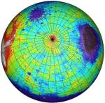 Southern Mars
2.12.1999
This topographical map of the southern hemisphere of Mars was generated using data from the Mars Orbiter Laser Altimeter (MOLA). Flying on the Mars Global Surveyor spacecraft, MOLA has bounced a laser beam off the Martian surface over 200,000,000 times producing a wealth of detailed elevation measurements.
 APOD: 2025 July 6 ┴ The Spiral North Pole of Mars
5.07.2025
Why is there a spiral around the North Pole of Mars? Each winter this pole develops a new outer layer about one meter thick composed of carbon dioxide frozen out of the thin Martian atmosphere. This fresh layer is deposited on a water-ice layer that exists year round.
|
January February March April May June July |
|||||||||||||||||||||||||||||||||||||||||||||||||