|
|
You entered: landsat
 Landsat 7 Views Planet Earth
14.05.1999
Launched last month, NASA's Landsat 7 spacecraft now orbits planet Earth. Looking down from an altitude of 700 km, Landsat 7 can map the planet's surface in visible and infrared bands and resolve features 30 meters across or smaller.
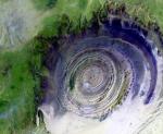 Earths Richat Structure
28.10.2002
What on Earth is that? The Richat Structure in the Sahara Desert of Mauritania is easily visible from space because it is nearly 50 kilometers across. Once thought to be an impact crater, the Richat Structure's flat middle and lack of shock-altered rock indicates otherwise.
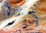 Terkezi Oasis in the Sahara Desert
12.11.2002
Dominating the top third of Africa is the largest band of dry land on Earth: the Sahara Desert. Stretching across the Sahara are vast planes of sand and gravel, seas of sand dunes, and barren rocky mountains.
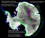 The Coldest Place on Earth
11.12.2013
How cold can it get on Earth? In the interior of the Antarctica, a record low temperature of -93.2 C (-135.8 F) has been recorded. This is about 25 C (45 F) colder than the coldest lows noted for any place humans live permanently.
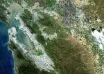
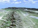 Earths San Andreas Fault
7.12.2000
The Earth's surface is broken. Cracks in the Earth's crust known as faults can run for hundreds of kilometers. These faults are frequently the sites of major earthquakes as the tectonic plates that cover the surface of the Earth shift.
APOD: 2026 April 22 Á Earthset with an iPhone
22.04.2026
What does it mean for the Earth to set? Artemis II Commander Reid Wiseman gave us another spectacular view of Earth from their historic flyby of the Moon. Commander Wiseman's video, taken with an iPhone at 8x zoom, shows our entire planet gradually blocked from view by the Moon.
|
January February March April May June July |
|||||||||||||||||||||||||||||||||||||||||||||||||