|
|
Keyword: weather
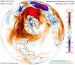 Cold Weather Delayed over North America
15.11.2016
Why is it so warm in northern North America? Usually during this time of year -- mid-November -- temperatures average as much as 30 degrees colder. Europe is not seeing a similar warming. One factor appears to be an unusually large and stable high pressure region that has formed over Canada, keeping normally colder arctic air away.
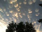 Mammatus Clouds Over Saskatchewan
23.10.2012
Normal cloud bottoms are flat. This is because moist warm air that rises and cools will condense into water droplets at a specific temperature, which usually corresponds to a very specific height. As water droplets grow, an opaque cloud forms.
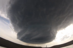 A Supercell Storm Cloud Forming over Wyoming
21.05.2014
How do supercell storm clouds form? Pictured above is a time-lapse video taken last Sunday detailing the formation of one such violent supercell in eastern Wyoming, USA. Starting as part of a large and dark thunderstorm complex, the supercell comes together along with a large rotating updraft of air known as a mesocyclone.
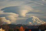 Lenticular Clouds Over Washington
4.11.2012
Are those UFOs near that mountain? No -- they are multilayered lenticular clouds. Moist air forced to flow upward around mountain tops can create lenticular clouds. Water droplets condense from moist air cooled below the dew point, and clouds are opaque groups of water droplets.
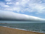 A Roll Cloud Over Uruguay
5.01.2010
What kind of cloud is this? A roll cloud. These rare long clouds may form near advancing cold fronts. In particular, a downdraft from an advancing storm front can cause moist warm air to rise, cool below its dew point, and so form a cloud.
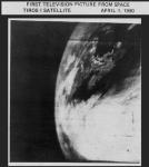 Planet Earth From TIROS 1: First TV Image
1.04.2000
The Television InfraRed Observational Satellite (TIROS) 1 was the first weather satellite. Launched into a polar orbit 40 years ago (April 1, 1960) equipped with two TV cameras, TIROS 1 was operational for only 78 days but demonstrated the feasibility of monitoring planet Earth's cloud cover and weather patterns from space.
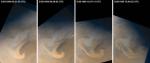 Mars Weather Watch
16.08.1999
Mars may be a cold, dry planet but its weather is dynamic. On June 30, wide angle cameras on board the Mars Global Surveyor (MGS) spacecraft watched the development of this large scale storm system above Mars' north polar area.
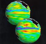
 El Nino Earth
12.11.1997
El Niño is a temporary global climate change resulting from unusually warm water in the central Pacific Ocean. El Niño can cause unusual or severe weather for some locations over the next few months.
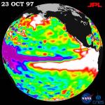
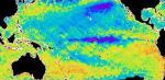
 El Nino Water Rhythm
13.01.1998
This year's El Niño is the strongest ever recorded. The large amount of warm water in the Pacific Ocean near the equator is causing unusual weather all over planet Earth.
 La Nina Watch
20.07.1998
Goodbye El Niño. Hello La Niña? Scientists are watching to see if an evolving pool of relatively cool water in the mid-Pacific Ocean will develop into a full "La Niña". Over the past several months, the water temperature in the Equatorial Pacific Ocean has been doing a flip-flop.
|
January February March April |
|||||||||||||||||||||||||||||||||||||||||||||||||