|
|
You entered: radar
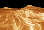 A View from Venus: Rift Valley
24.06.1996
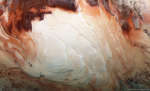
Color information from the Soviet Venera landers and radar data from the Magellan spacecraft were used to construct this striking perspective view of the Venusian landscape. (In this computer generated image, the vertical scale has been exagerated.) In the foreground is the edge of a rift valley created by faulting in the crust of Venus.
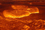 Venus Once Molten Surface
1.08.2010
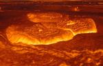
If you could look across Venus with radar eyes, what might you see? This computer reconstruction of the surface of Venus was created from data from the Magellan spacecraft. Magellan orbited Venus and used radar to map our neighboring planet's surface between 1990 and 1994.
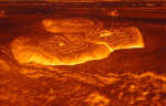 Venus Once Molten Surface
23.06.2013
If you could look across Venus with radar eyes, what might you see? This computer reconstruction of the surface of Venus was created from data from the Magellan spacecraft. Magellan orbited Venus and used radar to map our neighboring planet's surface between 1990 and 1994.
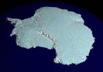 A RADARSAT Map of Antarctica
15.11.1999
It's not easy to make a map of Antarctica. Earth's southern most continent is so cold and inhospitable that much of it remains unexplored. From space, though, it is possible to map this entire region by radar: by systematically noting how long it takes for radio waves to reflect off the terrain.
 Layers of the South Pole of Mars
30.07.2018
What lies beneath the layered south pole of Mars? A recent measurement with ground-penetrating radar from ESA's Mars Express satellite has detected a bright reflection layer consistent with an underground lake of salty water. The reflection comes from about 1.5-km down but covers an area 200-km across.
 Venus Once Molten Surface
16.09.2001
If you could look at Venus with radar eyes - this is what you might see. This computer reconstruction of the surface of Venus was created from data from the Magellan spacecraft. Magellan orbited Venus and used radar to map our neighboring planet's surface between 1990 and 1994.
 Sky Full of SARs
16.08.2024
On August 11 a Rocket Lab Electron rocket launched from a rotating planet. With a small satellite on board its mission was dubbed A Sky Full of SARs (Synthetic Aperture Radar satellites), departing for low Earth orbit from Mahia Peninsula on New Zealand's north island.
 Venus Unveiled
9.02.2019
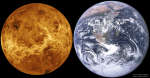
What does Venus look like beneath its thick clouds? These clouds keep the planet's surface hidden from even the powerful telescopic eyes of Earth-bound astronomers. In the early 1990s, though, using imaging radar...
 Soaring over Titan
23.11.2014
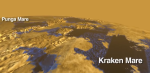
What would it look like to fly over Titan? Radar images from NASA's robotic Cassini satellite in orbit around Saturn have been digitally compiled to simulate such a flight. Cassini has swooped past Saturn's cloudiest moon several times since it arrived at the ringed planet in 2004.
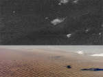 The Sand Dunes of Titan
10.08.2010
Why do some sand dunes on Titan appear backwards? Central Titan, it turns out, is covered by sand, some of which appears strange. Images from the Cassini spacecraft currently orbiting Saturn have uncovered long rows of huge sand dunes near Titan's equator that rise as high as 300 meters.
|
January February March April |
|||||||||||||||||||||||||||||||||||||||||||||||||